The Hockanum River Linear Park Committee is a subcommittee of the Conservation Commission, formed in 1970. This group of volunteers maintains the approximately 15 miles of hiking trails along the Hockanum River. They work to preserve scenic woodlands, wetlands and wildlife along the river; as well as provide well maintained hiking trails for public recreation. To learn more about the 9 trails they maintain, please click Next below.
1. Before exploring any hiking trail, have a trail map or use a hiking app to help you navigate.
2. Always let someone know exactly which trail you plan to hike and when you expect to return home.
3. Carry a cell phone with a well charged battery.
4. Bring a hiking partner if possible, it is safer than hiking alone.
5. Plan your hike to be off the trail before dark. Select a trail that matches your hiking abilities, so it is not too long or too difficult.
6. Hockanum River trails are for hiking, jogging, cross country skiing and snowshoeing. ALL VEHICLES ARE PROHIBITED per Town Ordinance, this includes bicycles, dirt bikes, e-bikes, all terrain vehicles and snowmobiles.
7. Hockanum River trails are marked with single orange blazes at intervals and a pair of blazes at each turn, with the top blaze indicating the direction of the turn. If you do not see a blaze ahead, you may have strayed off trail. Backtrack to the last blaze and follow the blazes again.
8. Respect the environment - Take only pictures, leave only footprints. Please do not litter, do not disturb wildlife and stay on the trails. Please also refrain from picking wildflowers, leave them so others may enjoy their beauty as well.
9. If you are fishing, please remember the Hockanum River in Manchester is designated by the CT DEEP as Catch & Release only. A fishing permit is required.
10. If you become ill or injured, or are lost and cannot find the trail back to the trailhead, call 9-1-1 and explain as precisely as possible where you are located -- which trail by name and location, which side of the river you are on, and how far away from the nearest street you believe you are. Please remember: Orange blazes always lead out to Town streets.
11. Hockanum River hiking trails, as with all Manchester Town parks, close between dusk and dawn. Parking after those hours is not allowed. In addition, alcoholic beverages and camping are not permitted.
Distance: Approx. 2.0 miles
Parking: Kohl's parking lot at 155 Tolland Turnpike, towards the right-hand side of the store. A brown sign reading "TRAIL" with a "no bikes" symbol marks the trail entrance.
This is a loop trail that runs alongside I-84, behind multiple businesses with a return along the south side of the river. Downstream you will cross a Boy Scout footbridge and enter the woods, where the path follows close to the river through meadow and forest. Upstream the path will go up and across a 20 foot bridge through a small meadow. While you should expect traffic noise on this trail, it does offer scenic beauty of the river, water birds and wildflowers.
Of special note: Roughly 50 feet from the trailhead, the path splits. Straight ahead are 5 steps down to a 30 foot wood bridge with railings, which crosses the river to 4 acre Doug Smith Island. This island in the river has a 0.4 mile scenic loop trail through meadow and forest. Deer frequent this area!

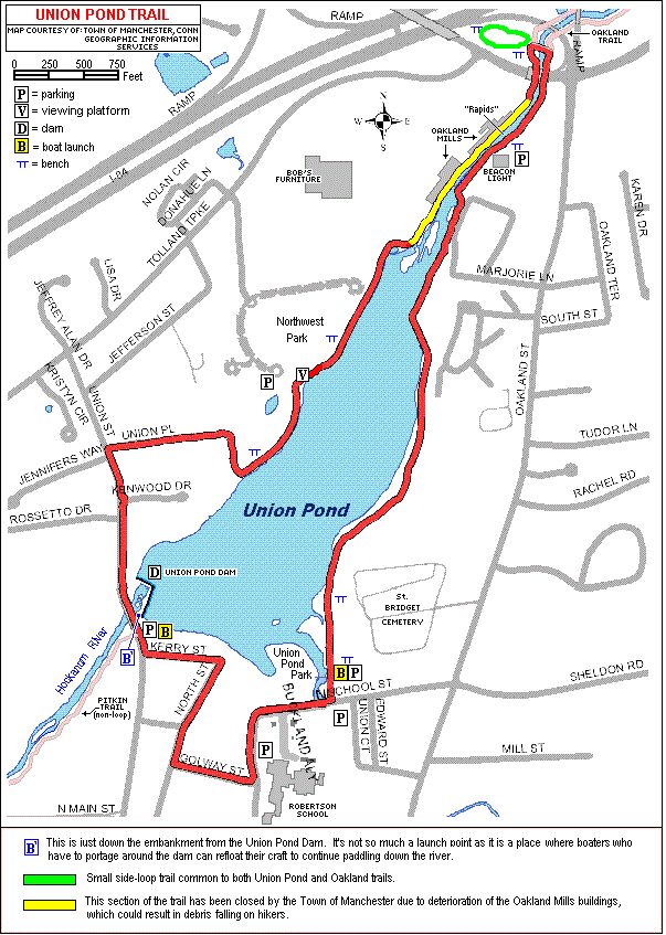
Distance: Approx. 2.4 miles
Parking: There are 3 parking options:
- Robertson School, 65 North School St., just north of the Main/North Main St. intersection.
- The lot across from Union Pond Park, cross the street to the driveway of the boat launch site. (There is a small parking area at the boat launch site itself.)
- Parking lot off Oakland St, near the Beacon Light store; access to both upstream and downstream hiking is available from this entrance.
This is a hilly walk around the Town of Manchester's 60 acre pond. Hikers may see wildflowers, water birds and an abandoned historic paper mill. The pond and trail are hidden from the nearby roads. It is surrounded mostly by mature forest on the east, as well as a few apartments and scattered homes.
There is also quiet Union Pond Park with a braille trail, a dock on the south and a skating pond in winter. On the west side is Northwest Park with an observation deck, 2 baseball fields, garden and picnic pavilion.
Union Pond hosts a large number of water birds: Canada geese, sea gulls, mallards, cormorants and others year round. More infrequent visitors include osprey, great blue heron, great egret and passing Bald Eagles looking for open water during winter.
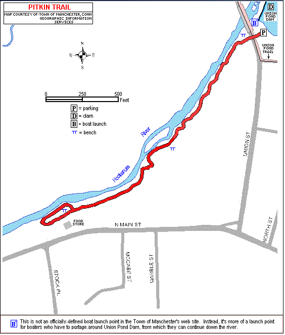
Distance: Approx. 0.4 miles
Parking: East side of Union St. next to the Union Pond Dam.
Spectacular views of the 60 acre pond and dam with water spilling over are seen from the parking lot, more views of the dam can be seen from the base of the steps down under the Union St. Bridge. The trailhead, marked with a "Hockanum River Hiking Trail" sign, is across the street. Hiking proceeds downstream for 0.4 mile and returns over the same course.
This trail is one of the most scenic, hilly and tranquil along the Hockanum River. The path winds through a lush green forest valley, totally away from any traffic noise. The trail immediately goes down a flight of steps to a sandstone ledge close above the river, with great views of the bridge and dam upstream and of the waterway off to the left. Orange blazes guide hikers as the path wanders up and down slopes, through wetlands and over 2 brooks on small footbridges.
Fauna along this trail includes white tail deer, rabbits, wild turkeys and woodchucks. Flora includes mostly forest trees such as oak, maple, white ash and black cherry. Wild flowers are scarce due to the dense tree canopy.
Distance: Approx. 1.9 miles
Parking: Elicit Brewing Co. (formerly the Adams Mill Restaurant) parking lot, 165 Adams St. - to the far left of the lot.
The trail begins with a short hike up the side of a dike, where you go left across a historic water gate on a footbridge.
Across the footbridge, the trail proceeds back along the top of the old earthen dike and curves around to the right. Past the curve you'll find a side-fork which bears left, while the main right fork goes behind several modern industrial buildings, continuing straight towards the river.
Fun History Fact: the earthen dike you are walking along contained the 30-acre Adams Pond for the mill's water power!
Near the end of the dike the path goes down a flight of steps on the left, with the river ahead. At the bottom, a short side trip to the right, down the river, gives hikers a view of the old sandstone dam ruins and the frame of the brick hydroelectric structure built by E.E. Hilliard Company around 1907. This dam burst during the great New England Hurricane of 1938. Returning to the main river trail, it goes upstream along the river, always following orange blazes. Nearby is a side trail, back into the woods, to an earlier dam with some modern-day carvings, this dam dates back to 1867.
Back on the main trail, following the river upstream will lead you past many Mountain Laurel and provide a breathtaking view of the river below. The trail then continues out to the railroad tracks and trestle, built in 1850.
PLEASE NOTE: Hikers should not cross the railroad bridge to get to the south side of the trail. Instead, those who wish to hike the other side should backtrack to Adams St. and cross the small Adams St. bridge over the Hockanum River to get to the south side of the river, and trail access behind the car dealership.

Distance: Approx. 0.75 miles
Parking: Enter the softball field entrance on New State Rd, parking for the trail is off to the right.
This is an easy, scenic loop trail great for a leisurely walk or jog; or in the winter, cross-country skiing and snow shoeing. This trail loops around a 20-acre parcel of land owned by the Town of Manchester. It is relatively flat, former farm land. There is a mature hardwood forest and flood plain, partially abutting the Hockanum River. Wildflowers are not abundant along this trail due to deep woodland cover, however deer are often around the area as well as occasional meadow birds. Along the river a Great Blue Heron or Belted Kingfisher sighting is possible.

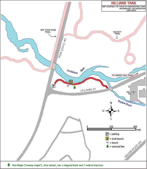
Distance: Approx. 0.15 miles
Parking: Lot at the corner of New State Rd. and Hilliard St.
From the parking lot the trail proceeds upstream to the river junction where Bigelow Brook enters the Hockanum. The trail ends on Hilliard St.; or connects east on Hilliard St. past the Hilliard Mills to the corner of Hilliard and Adams Streets. If you continue to follow the river upstream, you will eventually reach the Adams Mill Trail.
Hilliard Trail is a very short segment in the woods that runs closely along the river, offering nice views of the waterway, a boat launch and open spots for fly fishing. Although short in length, the trail offers a tranquil river view. Sit and relax on the bench or one of two picnic tables. This trail is a great spot for bird watching; mallards and Canada geese frequent this area, as well as an occasional visit from a Great Blue Heron or Belted Kingfisher. It is also a convenient location for launching a kayak or canoe to explore the river.
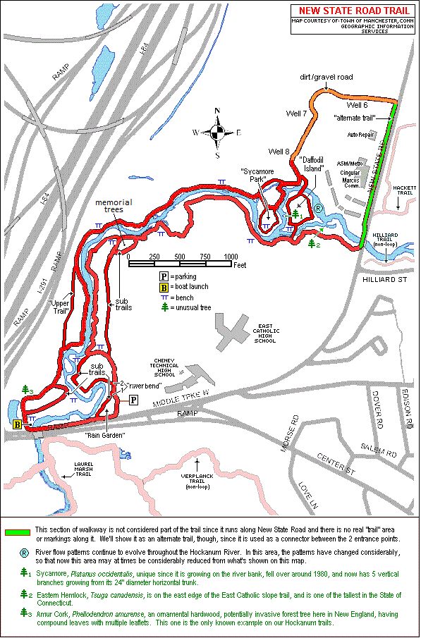
Distance: Approx. 2.8 miles
Parking: West of Cheney Technical High School, Student Parking Lot on Middle Turnpike West.
A short set of steps at the trailhead will lead to a short grassy access path to the main Eversource driveway. Follow this driveway to the right for roughly 50 feet, past River Bend Trail #1, which goes left of the Hockanum River Dock for launching kayaks and canoes. Just beyond, take the second left, River Bend Trail #2, which will take you through wetland upstream, over two bridges crossing a small pond and brook. From there the trail curves around along a backwater section of the river and a gradual upslope, offering better views of the rapidly moving river and expansive marsh beyond. Continuing on you will find a bench to sit and take in the view, possibly catching a glimpse of a beaver! Past the bench the trail goes on through a Memorial Tree Planting area of past Committee volunteers, there you will find White and Austrian Pine and another bench for relaxing. Ahead, the trail winds through deep forest and wetland along the river and out to an over 40 foot bridge, built by the Boy Scouts in 2005, which crosses a seasonal pond.
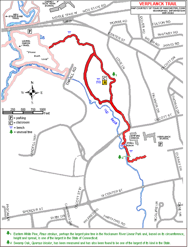
Distance: Approx. 0.75 miles
Parking: Laurel Marsh Parking Lot on Middle Turnpike West, across from Cheney Technical High School - or - in the Verplanck School Parking lot.
Beginning from the Laurel Marsh lot, you will follow the stone dust trail as it curves around, then makes a sharp left at a sign reading "Olcott Street". You will then follow a wood chip path through beautiful, mature forest, over several boardwalks. The trail then curves around the Water Pollution Control Plant, passes through a wetland via multiple boardwalks, over a berm leading to a deep woodland of pines and hardwoods. The trail will pass an outdoor classroom of wooden benches used by Verplanck Elementary School for class hikes. You will then cross a dirt road to the Leber Baseball Field, where the trail will will follow a woodland course about 50 feet away from the Hop Brook. The trail will come out at the corner of Love Ln. and Olcott St. There is an additional section of the Verplanck Trail across Olcott St., just to the right of Empire Industries, in the driveway of the Eversource substation and cell tower. This trail extension follows upstream close to the scenic Hop Brook, curving around behind Empire Industries and ending at a set of steps leading to the rear playground of Verplanck School.
*Verplanck School classes regularly use this trail for nature study hikes and outdoor classroom during spring and fall. Various classes practice snowshoe exercises and wildlife tracking activities during winter.
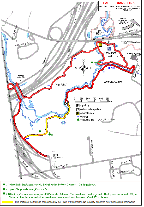
Distance: Approx. 3.5 miles
Parking: Laurel Marsh Trail parking lot, Middle Turnpike West, across from Cheney Tech High School
The first 3/4 mile loop trail is stone dust or grass and is accessible for disabled persons. This loop is mainly flat with 2 gentle slopes. Views include forest, meadows, wetlands and sections of the Hockanum River and Hop Brook. Down 3 steps you will find a boat launch and easy crossings on several small footbridges. You will find panoramic vistas, wild flowers, numerous opportunities for bird watching over land and water, plus close access to the water for fishing.
The main hiking path, off to the right from the trailhead, heads west towards the river and through the woods. You will come upon a boat launch which provides a good stop to put your kayak or canoe in the water for a leisurely, scenic 1-hour trip winding downstream through the marsh, with takeout just to the right of the Powder Mill Dam in East Hartford. If you are staying on land, the trail will cross the Hockanum's main footbridge and then on to a boardwalk through diverse wet woodland foliage. You will then come across your first view of the expansive Laurel Marsh. In season you will find copious displays of Purple Loosestrife, purple flowering pickleweed and cattails. Here you will also find a bench overlooking Pond Number One, 1 of 12 excavated by the State DEEP to enhance the diversity of the marsh. These ponds are filled with tadpoles, frogs and some small fish. Occasionally you will see mallards and Canada geese. You may also spot wood duck boxes, installed by the Committee volunteers, on trees or posts near the water.